LIFTED: BOIL WATER NOTICE for 200 Church, 205 Church, 209 Church, 211 Church, 217 Church, 223 Church, 225 Church, 174 Maple is LIFTED.
You can resume using your water without boiling it. Visit Boil Water for more details.
LIFTED: BOIL WATER NOTICE for 200 Church, 205 Church, 209 Church, 211 Church, 217 Church, 223 Church, 225 Church, 174 Maple is LIFTED.
You can resume using your water without boiling it. Visit Boil Water for more details.
What's New:
North Avenue is a crucial corridor for parents and students traveling to and from neighborhood and magnet schools in Burlington. If parents, students, staff, and/or administrators have any feedback on the pilot project or would like to learn more, please contact DPW.
For More Information:
Please contact Nicole Losch - Email: northavepilot@burlingtonvt.gov Phone: 802-863-9094 x3

Opportunities for Public Input
Project Links
Public Opinion Survey Report - fall 2016
Crash Analysis:
July 2016 - April 2017
July 2016 - Sept 2016
Pilot Project Data
Pilot FAQs
Road Segment Concepts:
June 7 presentation and video
Sept 20 presentation and public forum comments
Oct 17 presentation and 1st Quarter Report to Council
![]()
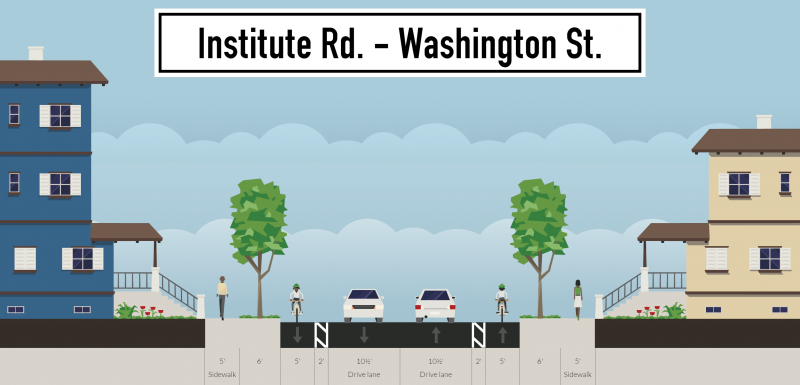
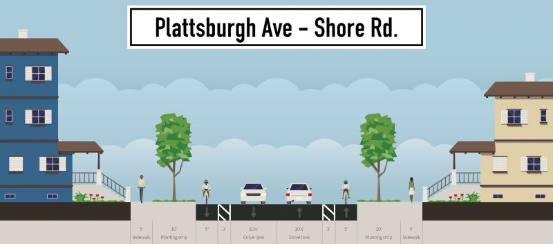
The North Avenue Pilot Project involves signal improvements, measures to make North Avenue safer for vehicles, pedestrians, and bicyclists, and temporary restriping and intersection changes between Washington Street and Plattsburg Avenue. These changes were recommended in the North Avenue Corridor Study the first phase of a three-phase process for making North Avenue a “Complete Street”
The North Avenue Pilot installation begin in June 2016. The 4-lane segments of North Avenue were reconfigured to 3 lanes, and bike lanes and other changes were made to enhance safety for pedestrians, bicyclists and motorists. For a comprehensive list of changes that were made, please click here.
The city hopes that these pilot measures will decrease the number of and the severity of crashes, calm traffic, reduce speeding and make North Avenue safer for cars, pedestrians and bicyclists, while still providing efficient traffic flow.
Results from the pilot will determine whether the middle section of North Avenue should optimally be designed with three or four lanes. This determination is critical as it will direct the design of future improvements called for in the corridor study including signalization, transit stops, crosswalks and bike facilities.
This is a pilot. All the modifications that will be made are reversible, and DPW is committed to removing modifications that are problematic.
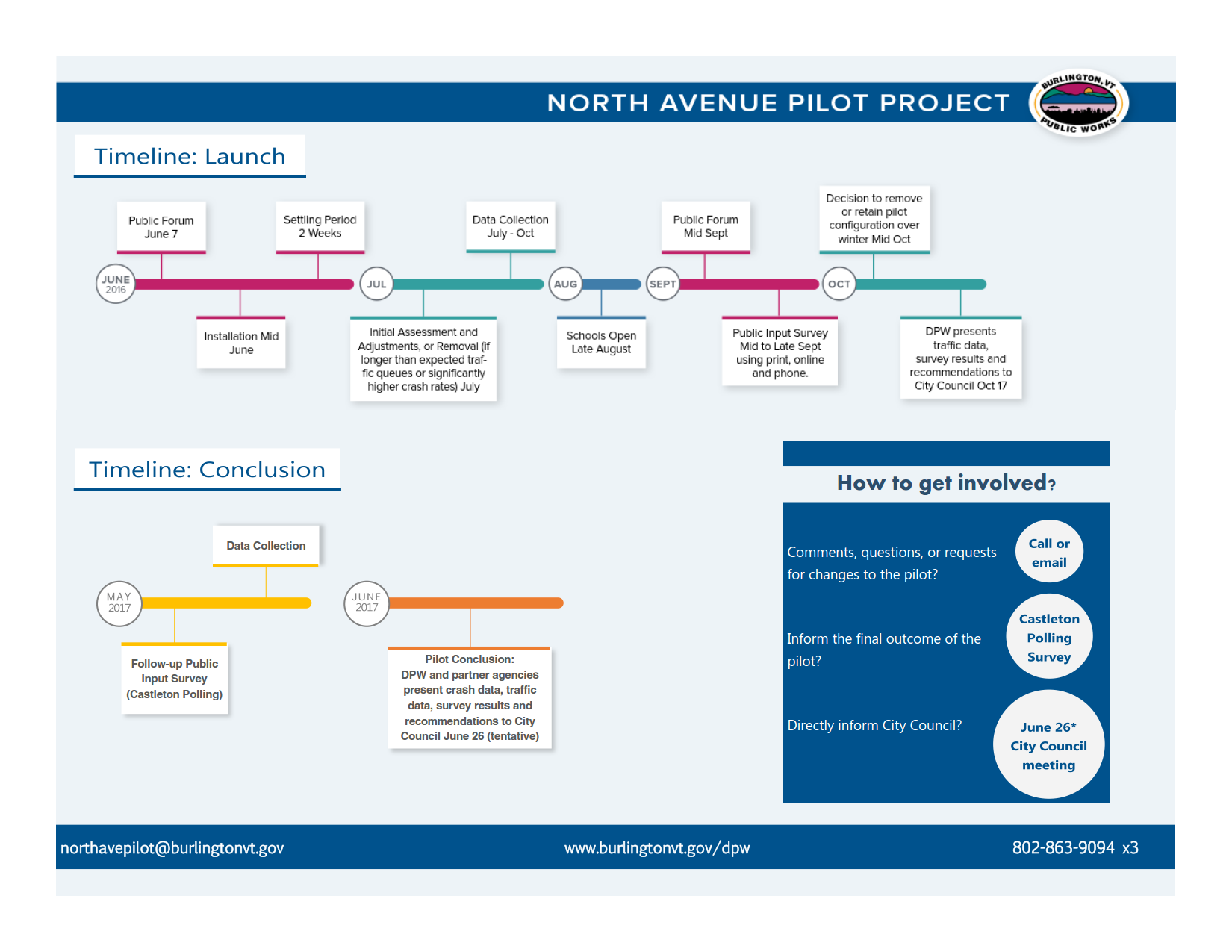
The pilot is designed to calm traffic while still providing efficient travel times, so if you are one of the 86% of drivers who were speeding on North Avenue prior to the pilot installation, your driving time is likely to increase slightly. As we prepared for the pilot, we projected a travel time increase of up to 2 minutes in either direction. The pilot project will provide data to determine what effect the roadway changes will have on driving times.
A vehicle traveling at the speed limit (30 mph) that received all green lights would take 1 minute and 36 seconds to travel the 0.8 mile 4-lane section. Travel time data collected during the morning and evening commute hours in June and November 2015 found that, on average, it takes about two minutes to drive northbound, and slightly over two minutes to drive southbound. With the pilot configuration installed in September 2016, travel time data collected during the morning and evening commute hours found that, on average, travel times increased approximately 30 seconds during the morning and 1 minute in the evening. This data is available in the 1st quarter report and will be updated based on new data collected in spring 2017.
DPW will continue to monitor travel times and will, as needed and as possible, make modifications to optimize roadway and intersection efficiency. If pilot components result in unacceptable increases in driving times, it will be removed.
![]()
Between 127 and Ethan Allen Parkway, 86% of cars speed, and between the Shopping Center and Shore Road, 46% of cars speed[1].
The crash rate on North Ave[2] is significantly higher than that for comparable roads statewide.[3] VTrans ranks high crash locations[4] on the 3,900 miles of federal aid highways in the state.
![]()
The pilot installation will cost approximately $155,000. DPW’s annual street and sidewalk capital budget is $2.4 million.
![]()
The City Council directed the Department of Public Works to:
![]()
Traffic Data files collected from the Pilot will be posted on this project website. "Before" data is available on the Corridor Study website.
Can the yellow lines be crossed?
Yes, the yellow lines can be crossed when it is safe to do so. Click here for a video depiction of how to use the center left turn lane.
Can buses be passed when they're stopped?
If it is safe to do so, buses may be passed when they're stopped.
How can I access the 127 now that the ramps are closed?
The 127 can be accessed from the signalized portion of the intersection on North Avenue.
What do the flashing arrows mean?
Flashing yellow arrows mean you may turn when it is safe to do so, yielding to oncoming traffic or pedestrians in the crosswalk. Flashing red arrows mean you may turn, after coming to a stop and ensuring it is safe to turn. For a quick video tutorial courtesy of MNDOT, visit https://www.youtube.com/watch?v=uIkanxT72KI.
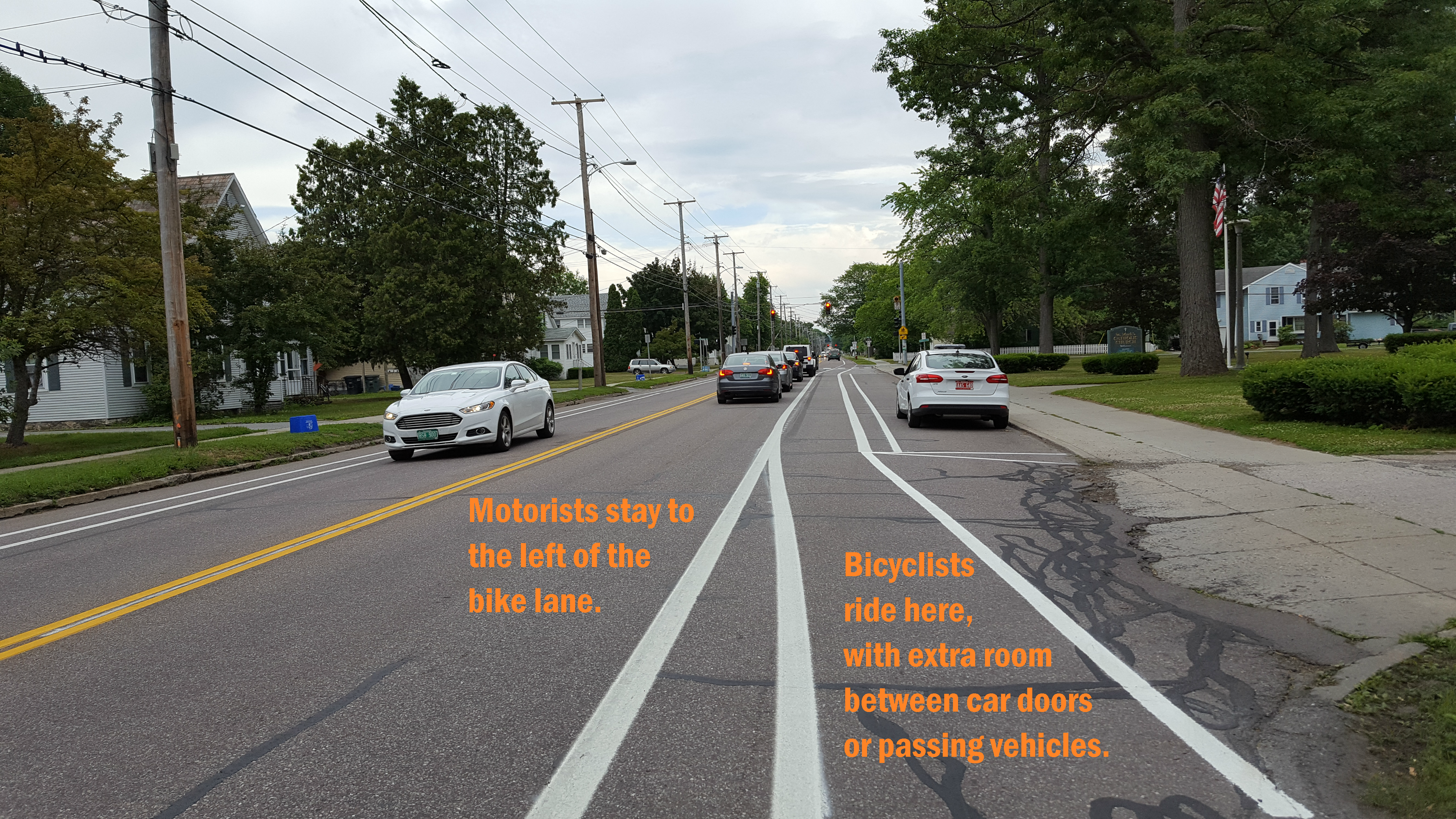
What are the double white lines north of Shore Road?
This area has a buffered bike lane, separated from motor vehicles by paint. If the new lane configuration is retained, the buffer area could be enhanced with additional paint, this area could become a protected bike lane, or the buffer could be removed to accommodate turn lanes or parking lanes.
What are the white lines north of the VT 127 intersection?
For the pilot project, areas with excess pavement have been marked with fog lines to keep a single lane in each direction. If the new lane configuration is retained, this area will be remarked to better distinguish the travel lanes, turn lanes, and bike lanes.
Q&A Related to the Protected Bike Lanes (removed in fall 2016)
What are the tall posts and low barriers in the roadway near BHS?
Because this is a pilot project to determine how a revised lane configuration on North Avenue works, we are testing ways to ensure everyone's safety by separating the bike lane from cars, trucks, and buses. If the new lane configuration is retained, we will consider other ways to separate the lanes, such as planter boxes or elevating the bike lane. Click here for more information on protected bike lanes.
We have installed two kinds of low-cost, removable lane separation devices for the pilot:
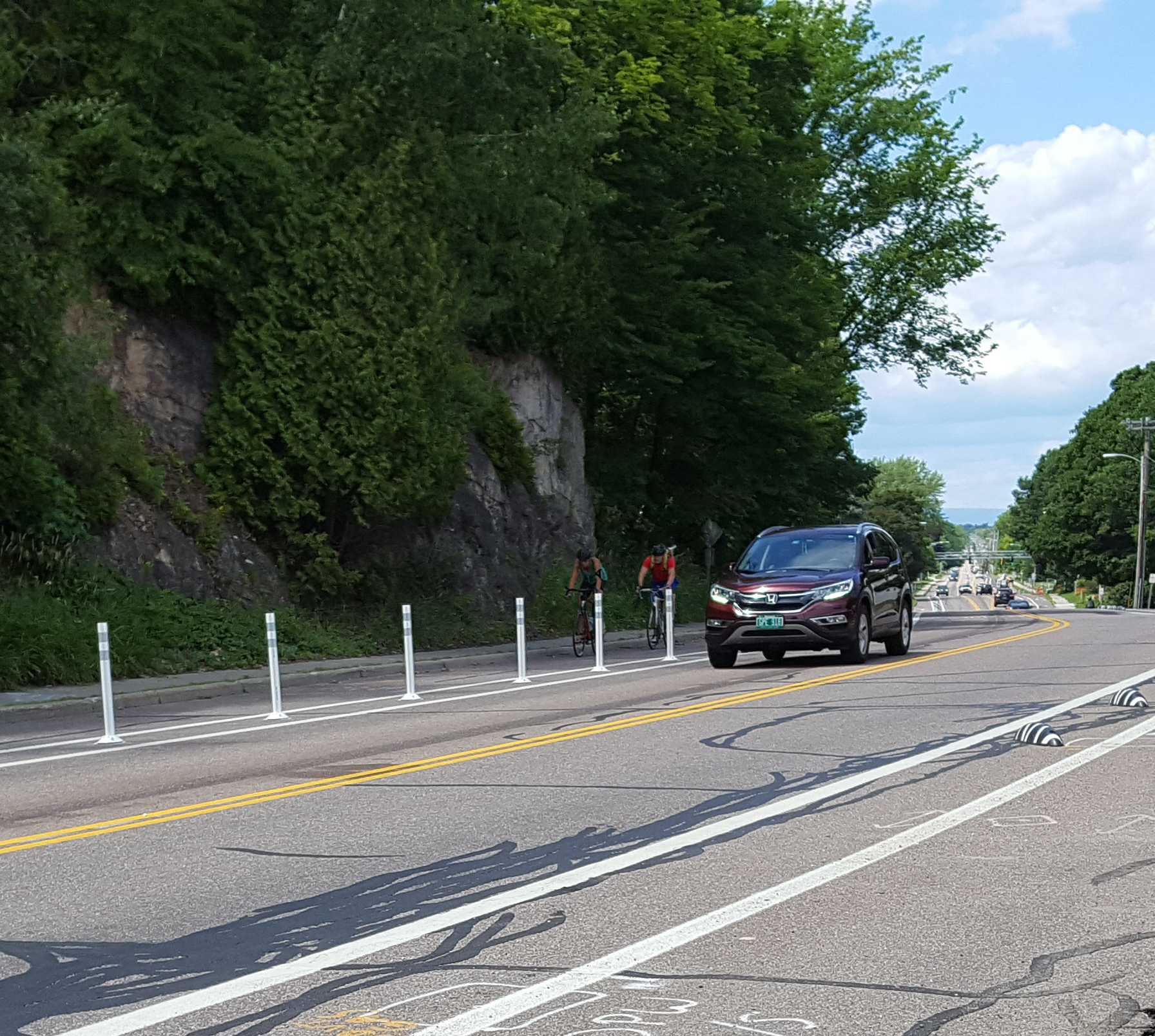

Bollards (also called flex posts) = vertical, flexible posts with reflective bands
Cycle lane delineators (also called "armadillos") = black and white oval mounds with reflective white stripes, accommodating passage of emergency vehicles and trash/recycling collection.
What happens to the protected bike lanes during winter?
The materials in use for the pilot will be removed for winter snow removal, and other materials can be applied if a protected lane is desired for any area of North Avenue in its final configuration. In response to concerns with the number of bollards and the lack of space to pull aside for emergency vehicles, we have removed many of the barriers to create less visual clutter and make more room to pull to the right. Let us know if what we've tried is or isn't working: Does the roadway seem less cluttered? Is it easier to pull aside? Is a protected lane desired over a painted bike lane, but not with these materials?
How can emergency vehicles pass?
Please put your hazard lights on and pull over to the right as far as possible. In order to make it easier for drivers to pull over near the protected bike lanes, we have increased the spacing of the bollards. If cars are traveling on both sides of the Avenue, it may be necessary to stagger vehicles or to pull off into a driveway to accommodate the emergency vehicle.
[1] Chittenden County Regional Planning Commission.
[2] This crash rate does not include crashes on side streets and in the shopping center.
[3] For more information on crash rates, please see pages 30-31 of the Corridor Study.
[4] High crash locations are locations that have 5 or more crashes in a 5-year period and have an Actual/Critical ratio of 1.0 or higher.


