How is Zoning Changing in this Part of Downtown?
The Downtown Mixed-Use Core Overlay (DMUC), approved by Burlington voters on November 8, 2016, codifies many of the central goals of planBTV Downtown & Waterfront and requires that new development in this part of downtown achieves a higher public benefit. Here are some of the key ways in which the DMUC will improve development outcomes within this part of downtown:
|
|
Previous "Downtown" Zoning |
Approved "DMUC Overlay" Zoning |
The purpose of the Change |
Other Details |
|
Height |
65 Ft. Maximum "by right," up to 105 Ft. Maximum using bonuses | 160 Ft. Maximum "by right" | planBTV identified the core of downtown as appropriate for taller buildings; the current bonus system is not utilized to achieve community benefits | DMUC allows buildings 4 stories and 55 Ft. higher than the previous zoning, a difference less than the height of the steeple recently replaced on the College Street Congregational Church. The DMUC maximum height is only 25 Ft. taller than the existing Masonic Temple on Church Street. |
|
Floor Area Ratio- FAR (FAR is a multiple of a site's area) |
Up to 8.0 FAR (Or, for every 1 Sq.Ft. of land area, there can be 8 Sq.Ft. of building on the land) |
Up to 9.5 FAR (Or, for every 1 Sq.Ft. of land, there can be 9.5 Sq.Ft. of building on the land) | Permit appropriate massing of buildings in the district consistent with the proposed height. | This allows 12% more building area in the whole overlay district than previously allowed. However, on the Burlington Town Center site, this permits 12% less building area than the old zoning due to the creation of two new street segments. |
|
Project Design- Urban Design Standards |
Limited, subjective design guidance relies on DAB & DRB to provide feedback to applicants | Prescriptive, objective design requirements consistent with the proposed Form-Based Code; more predictable design outcomes for project applicants and for the community | Achieve more community goals for active, vibrant, economically viable streets. | Because the Burlington Town Center site represents such a large redevelopment opportunity in downtown, the urban design standards are critical to ensure that new development activates the streets and that there are no long, continuous blank walls. |
|
Parking |
No restrictions as long as in compliance with Article 8 of the CDO | Prohibits surface parking; requires parking structures to be underground, behind a liner building, or above an active ground floor; requires parking at the edges of a building to be indistinguishable from other floors of a building; requires participation in a parking management district | Visible parking in front of buildings and/or visible from a pedestrian's perspective is highly detrimental to vibrant, active streets | |
|
Stormwater |
Manage stormwater runoff from 50% of new impervious surfaces | Manage stormwater runoff from 100% of new impervious surfaces | To address pollution, highest priorities are to slow down and reduce the amount of stormwater runoff reaching Lake Champlain | |
|
Green Buildings |
Not required | New development and substantial redevelopment required to be LEED Gold Certified or a nationally recognized equivalent | Buildings in this district should achieve the highest degree of energy efficiency and environmentally-sensitive design | |
|
Mixed Use |
Encourages mixed-use through optional bonuses | New projects are required to include both residential and non-residential uses | Significant new buildings should include a mix of uses to support the vision of planBTV | |
|
District Boundaries |
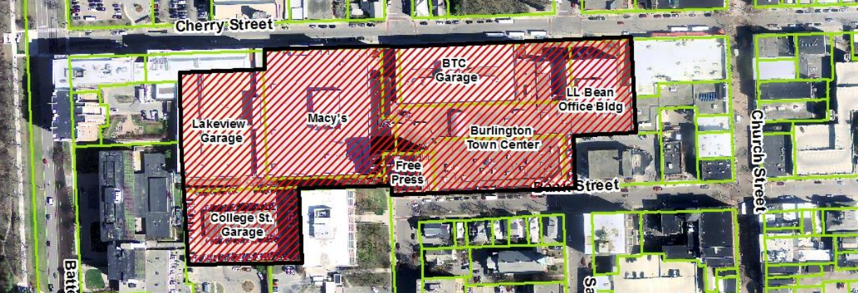
All properties between Pearl, Main, Battery, and Winooski (except City Hall Park) | Applies only to Burlington Town Center properties (including the L.L. Bean building), the Free Press Building, Macy's Building, and College Street and Lakeside garages (City-owned) | planBTV identified this part of downtown as appropriate for taller buildings; closely aligns with the Form Based Code Committee's area for taller buildings | The DMUC district applies to 8.7 acres of downtown, which is about 12% of the total downtown district. It applies to 7 properties and 4 property owners. |
|
Official Map |
Indicates new City Street connections at St. Paul and Pine Streets between Bank and Cherry Streets | Gives the City legal authority to exercise its right to purchase a property from a landowner before development can be approved | The reconnection of St. Paul and Pine Streets was a very ambitious goal set forth in planBTV Downtown & Waterfront; this change gives the City a tool through which this could become a reality. |
- Full Text of Approved Downtown Mixed Use Core Overlay zoning
- City Attorney Opinion on Consistency with PlanBTV
- Click here for a list of frequently asked questions